People saying “ya it’s called natural borders yank” as if they don’t come from countries where borders are decided instead by whoever was fucking over whichever disenfranchised minority group at any given time.
Also I actually think borders should be set at watershed boundaries instead of rivers since a lot of cities end up sprawling onto both sides of a river divide. The continental US should have 8 states,
Longhouse at the North Eastern watersheds,
Sherman along the southeastern, Tennessee Valley, and lower Mississippi watersheds
Ohiagan along the Ohio, Great Lakes, Upper Mississippi, and Sourris Red watersheds
Texas along the Rio-Grande and Texas Gulf watersheds
Buffalo along the Missouri and Arkansas watersheds
Sierra along the Colorado and Great Basin watersheds
I know what a watershed is, we’re talking about borders between states.
Draw a squiggly line that follows the river. You get the left side, I get the right side. The river moves as rivers do. After 100 years we do a survey and find I have a big chunk of property that used to be my side of the river but the river moved towards me and now that’s on your side of the river. I’ve lost some land due to some being on the other side of the river and more due to the land I used to have being a river now.
Is the boundary between us the water and we put up with the uncertain nature of our property, or do we honour the line drawn 100 years ago even though the river isn’t anywhere near there now?
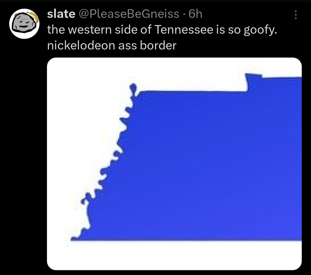
While using rivers to divide states may seem conceptually simple, the natural tendency of river courses to change over time has caused complications. If you look carefully at maps and legal history, there are numerous territorial oddities and disputes that have arisen over the years.
For instance, a series of earthquakes in 1811-12 shifted the course of the Mississippi River in a way that stranded two Tennessee towns—Corona and Reverie—west of the river in what seems like it should be Arkansas. Upstream, the same earthquake, and a lack of precision by early surveyors, left a bit of land known as the Kentucky Bend completely surrounded by parts of Missouri and Tennessee. Meanwhile, Kentucky and Indiana have engaged in a protracted debate about which state owned a piece of land near Evansville that connects to Indiana if the river is low but becomes an island if water is high.


People saying “ya it’s called natural borders yank” as if they don’t come from countries where borders are decided instead by whoever was fucking over whichever disenfranchised minority group at any given time.
Also I actually think borders should be set at watershed boundaries instead of rivers since a lot of cities end up sprawling onto both sides of a river divide. The continental US should have 8 states,
Longhouse at the North Eastern watersheds,
Sherman along the southeastern, Tennessee Valley, and lower Mississippi watersheds
Ohiagan along the Ohio, Great Lakes, Upper Mississippi, and Sourris Red watersheds
Texas along the Rio-Grande and Texas Gulf watersheds
Buffalo along the Missouri and Arkansas watersheds
Sierra along the Colorado and Great Basin watersheds
California at the California Watershed
Cascadia at the PNW Watershed
Counterpoint: I ain’t sharing a state with missouri
silence Missouri toucher
What happens when the river moves though?
WAR!!!
Nothing, the watershed boundaries are the points where water stops flowing towards one body of water and starts flowing towards another.
I know what a watershed is, we’re talking about borders between states.
Draw a squiggly line that follows the river. You get the left side, I get the right side. The river moves as rivers do. After 100 years we do a survey and find I have a big chunk of property that used to be my side of the river but the river moved towards me and now that’s on your side of the river. I’ve lost some land due to some being on the other side of the river and more due to the land I used to have being a river now.
Is the boundary between us the water and we put up with the uncertain nature of our property, or do we honour the line drawn 100 years ago even though the river isn’t anywhere near there now?
I’m pretty sure rivers don’t run along watershed borders. Which are the borders OP is suggesting.
That squiggly line is the Mississippi river.
You’re the only one talking about rivers in this sub-thread. Not that watershed boundaries can’t change.
🤮🤮
A chance to undo Ohio and he only made it bigger
Rename the Southeast to Sherman? I would like to subscribe to your newsletter.
Fun fact: watersheds are how we define our regions in NZ.
Though a region may consist of more than one watershed, but not less than one or a partial one.
You can’t make me do anything with Ohio