

You must log in or register to comment.
NEPA will not be happy about being considered “Upper Appalachia.”
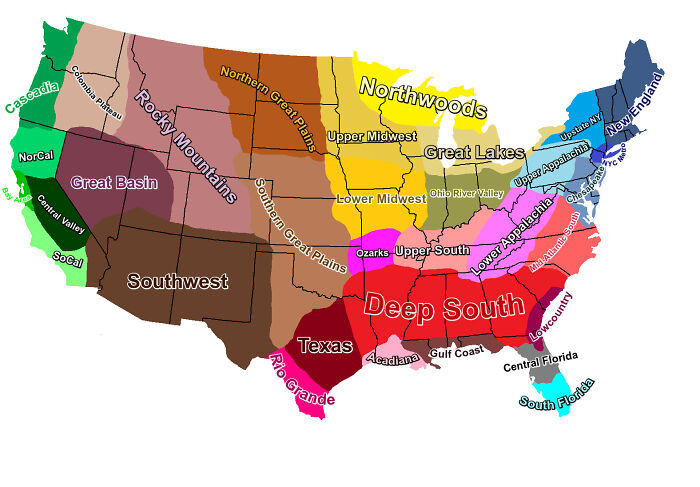
The Rocky Mountains extend into NE Washington state. The map is a very rough approximation at best.
Ohio River Valley actually extends to the WV border on the SE side (technically into it, but only like 1mi)
This guide is inaccurate. The region labelled midwest is actually in the east. And the region labelled deep south is actually in the northern hemisphere.
It would be pretty interesting if voting was broken down by these regions. It would probably be a lot more culturally representative.
Absolutely never will you catch a southern Illinois saying we’re from/in the south. We say Midwest or southern Illinois to be more specific.
I never understood why people think WV is a southern state. 1) It fucking snows and is cold af in winter. 2) We literally exist because we ain’t traitors.
It’s funny because I don’t know anyone east of Springfield that would consider themselves the “Ohio River Valley” either. I feel like the borders should be closer to state lines. I would like a reference for this map if anyone has it.
SoCal does not go up that far not even close. Gross
As a European, this map is excellent!
Don’t trust it. At best, some of it used to be accurate in a useful way. But even then, the terminology wouldn’t match well.
The closest you could get in comparison would be placing outlines of Prussia over modern Europe and saying that it was still a region. Yeah, there’s some connections, but it ain’t gonna help you much
It’s a lie. I’m sorry.
As a non-american, I have never heard of “northwoods” before.
I feel like this map was designed to piss off everyone.
Where’s the pacific northwest? It’s labeled weird.
All of Cascadia.
I refuse to be known at part of the nyc metro.
And I can drive a couple miles to a sign that says “Welcome to Tennessee, Gateway of the Deep South.”
You tell people they’re part of the “upper” south and they’ll set your car on fire.
New England is fully correct so no one there will be mad.
As is proper.
Jersey sure as shit ain’t “Chesapeake”.
Neither is Pennsylvania, this map is way off.
I feel like there’s a weird feral vibe in Philly anyway, Definitely should be a specific region.
Delaware Valley.
This might belong in no stupid questions but, what is the significance of Columbia? There seems to be no geographical consistency, it seems to be used accross several countries and languages. What’s the deal? Lol
Hahahahahahah holy fuck I never made the connection to Columbus. Fuck I’m dying cuz it’s so fucking obvious now hahaja
Nothing in Texas is part of the south. Not only will the south tell you that, Texas will tell you that
Well, they don’t even get all of Texas. So, who cares what they have to say. Can’t even keep their whole state. Who knew “Texas” was just a small chunk in the middle.
I’ve got some bad news for you hoss
Hard disagree. I lived in Dallas for 15 years. Longview and Tyler are classic Southern.
Some of these things seem solely topographical-based.
We should take this list and divide it into government districts. There are a lot of unhappy people and a lot of parts of states, conservatives in states where liberal centers control politics, and vice versa. This map corrects a lot of those areas of people with similar beliefs could be divided into similar districts.


